About Norgeskart Outdoors
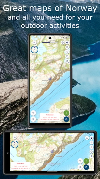
Norgeskart Outdoors has everything you need for your outdoor activities. Be it hunting and fishing, hiking, cycling, skiing or boating. All functions and content can be made available even without mobile coverage. -...
Norgeskart Outdoors has everything you need for your outdoor activities. Be it hunting and fishing, hiking, cycling, skiing or boating. All functions and content can be made available even without mobile coverage.
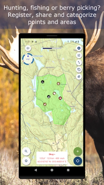
- Register, measure and categorise -
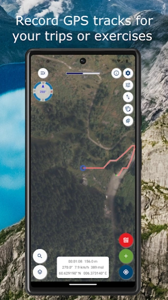
Register points of interest, routes, areas and record tracks. Organise the data by creating your own categories with colors and styles/icons for each category. If desired, your data can be written and read to/from GPX files or synchronised across devices and the map portal norgeskart.avinet.no. You can also easily share files with others from the lists of data in the app.
- Great outdoor maps and map layers -
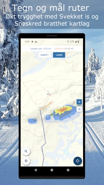
Choose from more than 40 maps and map layers. Beautiful maps of Norway from the Norwegian mapping authorities can be downloaded before you go on a trip for offline use. Many apps only let you turn on one layer at a time, here you can combine as many layers as you wish to create a complete overview of your surroundings. E.g. by turning on Pistes, Avalanche steepness and Weak ice layers.
- Own map and map layers -
Are you missing a map or map layer? The app now supports adding your own maps and layers from WMS, WMTS, XYZ and TMS services. A great source for additional maps and layers in Norway is the site geonorge.no. You can also try adding maps from other countries, but the app only support Mercator and UTM33 projections.
- TellTur -
Plan your next trip with trip suggestions and descriptions from telltur.no. With TellTur you can use the app to register when you arrive at a tour destination and compete with others to visit the most places.
This app contains both free and paid content (see complete overview below). By paying for a subscription, you support the further development of the app and take full advantage of all the exciting things we have to offer.
Free content:
------------------
- Topo and nautical maps for Norway, Svalbard and Jan Mayen
- View place name and heigh/depth for cursor position
- Search for place names, addresses or coordinates
- Import and export of GPX files
- Track recording with diagrams and details
- Create routes and POIs
- Compass
- Property borders
Pro subscription:
------------------
- (New) Create and measure areas
- (New) Create own categories
- Download Norwegian maps for offline use
- Topo map of Sweden (offline, but without download area function)
- Upload POIs, tracks and routes
- Synchronize your data across devices and with map portal
- Advanced properties layer (cadastre)
- Economic (N5 raster) map
- Historical map
- Mountain bike routes
- Pistes for Alpine and Cross-country
- Avalanche awareness, steepness and incidents
- Weak ice
- Snow depth and skiing conditions
- Snowmobile tracks
- Sea depths and lake depths
- Outports. Not nationwide.
- Conservation areas
- Clay and radon
- Open air routes summer and winter
- Activities (bath spots, campfires etc). Not nationwide.
- Facilities (toilets, parkings etc). Not nationwide.
Pro+ subscription (199 NOK a year):
------------------
- All in Pro
- (New) Orthophoto maps for Norway and Svalbard
- (New) Add your own maps and layers
- Periodic update of points from online KML files. Tested with TeleSpor.
Previous Versions
Here you can find the changelog of Norgeskart Outdoors since it was posted on our website on 2019-09-15 00:19:31.
The latest version is 3.23.1 and it was updated on 2024-04-22 13:17:03. See below the changes in each version.
Norgeskart Outdoors version 3.23.1
Updated At: 2024-04-08
Changes: 3.23.1:
- Improved memory handling to prevent possible stop in track recording.
- Fixed Jan Mayen map.
3.23.x:
- Added Orthophoto for Norway and Svalbard with Pro+ subscription
- Fixed tiles sometimes becoming blank if panning quickly back and forth.
- Fixed Svalbard FKB map.
Norgeskart Outdoors version 3.23
Updated At: 2024-03-24
Changes: - Added Orthophoto for Norway and Svalbard with Pro+ subscription
- Fixed tiles sometimes becoming blank if panning quickly back and forth.
- Fixed Svalbard FKB map.
- Added warning to TellTur trips that are not part of this year TellTur competitions (Vesterålen, Midt-Troms and Midtre Hålogaland has left TellTur).
Norgeskart Outdoors version 3.22.7
Updated At: 2024-01-16
Changes: 3.22.7:
- Fixed crash introduced in version 3.22.5 when checking for app updates on units with Android 14
- Fixed setting visibilities for categories.
- Prevent duplicates if screen turned on/off during download of data
- Some minor fixes
Norgeskart Outdoors version 3.22.5
Updated At: 2023-12-18
Changes: 3.22.5:
- Fix for tracker function
- Fix for selection in map when track start points have been grouped with other objects.
- Fix for setting of visibility from lists when tracks displayed as start points.
3.22.x:
- New Pro+. Add own maps and layers (WMS, WMTS, XYZ, TMS) for UTM33 or Mercator.
- Added support for west and south coordinates.
- Fixed log in on Android 5.x devices
Norgeskart Outdoors version 3.22.4
Updated At: 2023-12-09
Changes: 3.22.3:
- Fixed log in on Android 5.x devices
- Some improvements when adding own maps
3.22.x:
- New Pro+. Add own maps and layers (WMS, WMTS, XYZ, TMS) for UTM33 or Mercator.
- Added support for west and south coordinates.
Norgeskart Outdoors version 3.22.3
Updated At: 2023-11-27
Changes: 3.22.3:
- Added support for west and south coordinates.
- Some fixes and improvements
3.22.x:
- New Pro+. Add own maps and layers (WMS, WMTS, XYZ, TMS) for UTM33 or Mercator.
Norgeskart Outdoors version 3.22.2
Updated At: 2023-11-27
Changes: 3.22.2: Fixed some crashes
3.22.x:
- New Pro+. Add own maps and layers (WMS, WMTS, XYZ, TMS) for UTM33 or Mercator.
- Now supports Android 5.1 again
- Fixed Jan Mayen map
- Fixed hiding compass and ruler
- Fixed KML import
Norgeskart Outdoors version 3.22.1
Updated At: 2023-10-30
Changes: - New Pro+. Add own maps and layers (WMS, WMTS, XYZ, TMS) for UTM33 or Mercator.
- Now supports Android 5.1 again
- Fixed Jan Mayen map
- Fixed hiding compass and ruler
- Fixed KML import
Norgeskart Outdoors version 3.21
Updated At: 2023-09-22
Changes: - New design map screen
- New compass
- Change opacity for layers, lines and areas from new map button.
- Placename displayed in info box
- Duration and length displayed in list of tracks
- Fixes and improvements
Norgeskart Outdoors version 3.20.1
Updated At: 2023-09-07
Changes: - Create own categories with styles and colours.
- Filter by name in My data lists
- Topo map colour includes sea depth and has europe as fallback
- Sweden topo seamlessly integrated with Norway topo.
- Improved track recording
- More help in app
- Some fixes and minor improvements
Disclaimer
Official Google Play Link
We do not host Norgeskart Outdoors on our servers. We did not scan it for viruses, adware, spyware or other type of malware. This app is hosted by Google and passed their terms and conditions to be listed there. We recommend caution when installing it.
The Google Play link for Norgeskart Outdoors is provided to you by apps112.com without any warranties, representations or guarantees of any kind, so access it at your own risk.
If you have questions regarding this particular app contact the publisher directly. For questions about the functionalities of apps112.com contact us.